
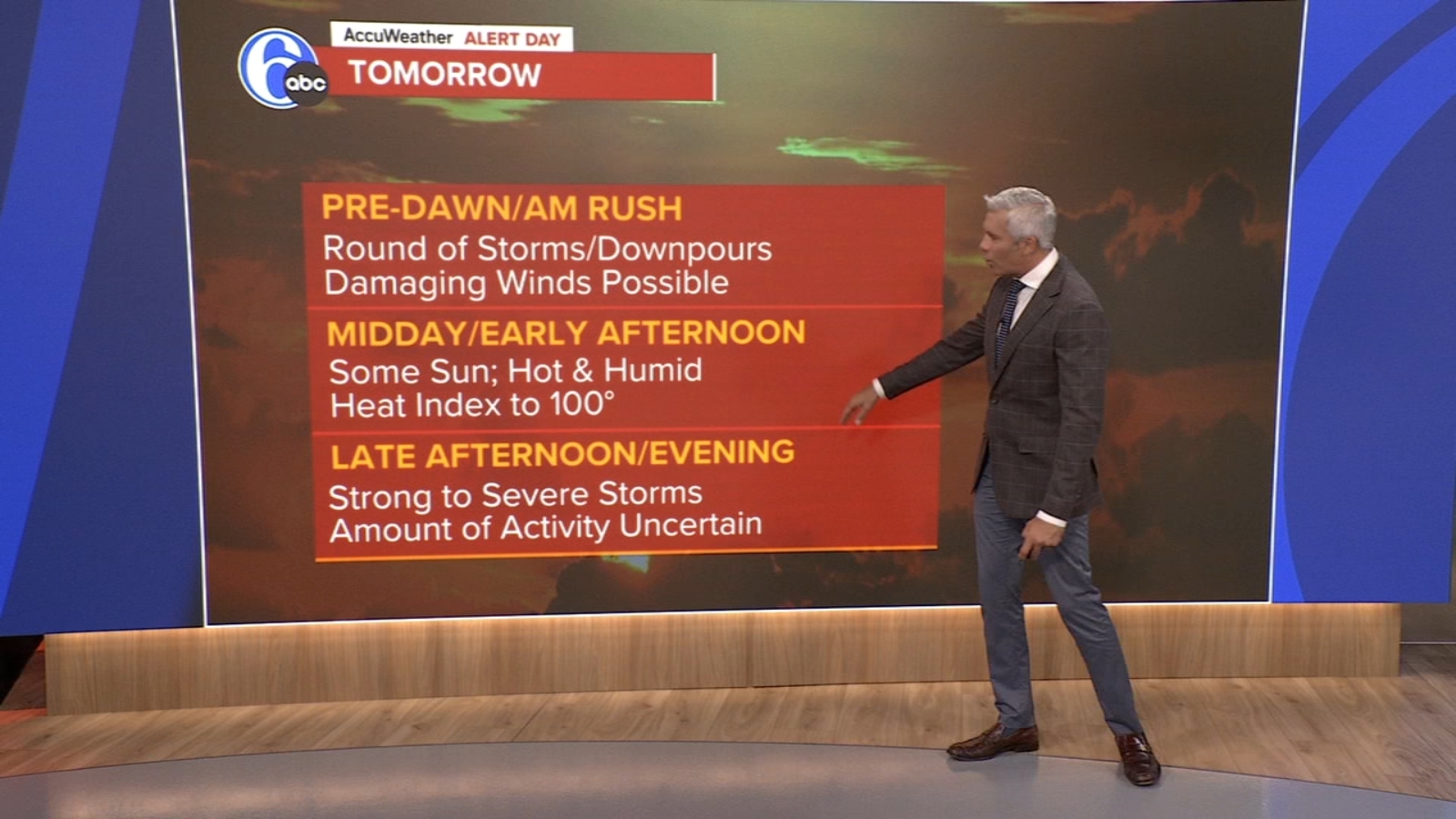
Residents across the Delaware Valley should brace for a turbulent day as the latest Philadelphia weather forecast calls for dangerous heat, oppressive humidity, and two distinct rounds of thunderstorms on Thursday. With a Heat Advisory already in place and the potential for damaging winds and even an isolated tornado, Thursday is shaping up to be one of the more volatile weather days of the summer. Here’s everything you need to know to stay safe and prepared over the coming days.
Overnight Setup: A Warm Front on the Move
The action begins before most people even wake up. Meteorologists tracking the Philadelphia weather forecast are watching a warm front pushing northward in the pre-dawn hours, and this boundary is expected to act as the spark for the first round of thunderstorms. These storms could pack a serious punch, with heavy rain, frequent lightning, and gusty winds. Depending on how quickly the front lifts through, some of these cells may linger into the morning commute, making the Thursday rush hour a potentially hazardous one.
Overnight temperatures will remain warm and muggy, with lows settling only into the lower 70s. That level of warmth and humidity overnight is a classic indicator that the atmosphere is loaded with energy, primed for severe weather once daytime heating kicks in.
Thursday’s “Bookend” Storm Threat
The standout feature in Thursday’s Philadelphia weather forecast is what forecasters are calling a “bookend” storm setup , meaning storms bookend the day on both ends, with a sweltering, dangerous break in the middle.
Round One: Pre-Dawn and Early Morning Storms
The first wave of storms is expected to roll through between roughly 4 a.m. and 8 a.m., tied directly to that warm front. Anyone heading out for an early commute should keep a close eye on radar and allow extra travel time. Ponding on roadways, downed tree limbs, and reduced visibility are all possible during this morning round.
The Heat Advisory: Midday and Afternoon Danger
Once the morning storms clear, the Philadelphia region will be left baking under hazy, humid conditions. The National Weather Service has issued a Heat Advisory for the area, with the thermometer expected to climb to a high of around 92 degrees. Factor in the humidity, and heat index values could push well into the upper 90s or even beyond triple digits.
This kind of heat is not just uncomfortable , it’s genuinely dangerous. Heat-related illnesses such as heat exhaustion and heat stroke become real risks, especially for outdoor workers, the elderly, young children, and anyone without access to air conditioning. Hydration, frequent breaks in shaded or air-conditioned spaces, and limiting strenuous outdoor activity during peak afternoon hours are strongly recommended.
Round Two: Late-Day and Evening Storms
Just when residents might think the day is winding down safely, a second round of strong to severe thunderstorms is expected to fire up late Thursday afternoon or into the evening hours. This is the more concerning of the two rounds from a severe weather perspective, as the atmosphere will be fully charged after a day of intense heating and moisture buildup.
The primary threats with these evening storms include:
- Damaging straight-line winds capable of knocking down trees and power lines
- An isolated tornado, which cannot be ruled out given the wind shear profile in the atmosphere
- Heavy rainfall that could lead to flash flooding in poor drainage areas
- Frequent cloud-to-ground lightning
The pattern is similar to what the region experienced just last night, when a powerful line of storms swept through the area. Residents are urged to remain alert, keep phones charged, and have multiple ways to receive weather warnings , including a NOAA weather radio and Wireless Emergency Alerts enabled on mobile devices.
Why This Setup Is So Volatile
The combination of an approaching warm front, abundant Gulf and Atlantic moisture, and strong daytime heating creates a textbook severe weather environment. When the upper-level dynamics of an approaching system combine with surface-based instability and sufficient wind shear, the result is often multiple rounds of organized convection , exactly what’s expected here.
Severe weather in Philadelphia during late summer isn’t unusual, but the dual-round setup on Thursday makes it especially important for residents to stay weather-aware throughout the entire day, not just during the morning rush.
Friday: A Cold Front Slowly Pushes Through
The good news embedded in the Philadelphia weather forecast arrives by Friday. A cold front will begin working its way through the region, although it will move at a sluggish pace. Friday will feature more clouds than sun, and the muggy air mass will still be hanging around. A few passing showers can’t be ruled out, but the instability will be nothing like Thursday’s explosive setup.
Highs on Friday will top out around 87 degrees, with continued humidity making it feel a bit warmer. While not as dangerous as Thursday, residents should still exercise caution if spending extended time outdoors.
Weekend Forecast: A Beautiful Relief
After two rough days, the weekend is shaping up to be a welcome reward.
Saturday: Sunny and Comfortable
Saturday brings mostly sunny skies, lower humidity, and a high near 83 degrees. It’s the kind of day Philadelphians hope for all summer , perfect for outdoor activities, trips to the Shore, backyard barbecues, or simply opening the windows and letting in some fresh air.
Sunday: Pleasant and Dry
Sunday looks just as inviting, with partly sunny skies, continued low humidity, and a comfortable high of 79 degrees. Whether you’re heading to a park, hitting the trails, or enjoying one of the city’s many outdoor markets, Sunday’s weather should cooperate beautifully.
Labor Day Monday: A Holiday Treat
The unofficial end of summer is also looking rather pleasant. Monday’s Labor Day forecast calls for a mix of sun and clouds with a high around 80 degrees. Beach trips, picnics, and family gatherings should all be largely unaffected by weather, though it would still be wise to keep an eye on any pop-up showers that sometimes develop along the coast this time of year.
For travelers heading to the Jersey Shore or Delaware beaches for the holiday weekend, conditions look favorable, with light winds, manageable surf, and comfortable temperatures throughout the day.
Looking Ahead: Tuesday and Beyond
The pleasant pattern continues into Tuesday, with partly sunny skies and a comfortable high of 83 degrees. There’s no major weather system on the horizon at this point, which is welcome news for anyone still squeezing in end-of-summer plans.
Looking further out, longer-range guidance suggests a relatively stable pattern taking hold across the Mid-Atlantic, with near-seasonal temperatures and no significant storm threats through the middle of next week. Of course, given how quickly patterns can evolve in late summer, it’s wise to check back for updates.
Staying Prepared: Quick Safety Reminders
Given Thursday’s enhanced severe weather potential, here are a few quick reminders to keep in mind:
- Know where to take shelter: If a tornado warning is issued, move to an interior room on the lowest floor of a sturdy building, away from windows.
- Secure outdoor items: Patio furniture, trash cans, and umbrellas can become projectiles in strong winds.
- Charge devices: Power outages are possible. Make sure phones, laptops, and backup batteries are fully charged.
- Never drive through flooded roads: Turn around, don’t drown , even shallow moving water can sweep a vehicle away.
- Check on vulnerable neighbors: During heat waves especially, check in on elderly neighbors, those without air conditioning, and anyone with medical conditions.
Final Thoughts
The Philadelphia weather forecast for Thursday is a clear reminder that late summer in the Mid-Atlantic can shift from sunshine to severe weather in the span of hours. With a Heat Advisory in effect, two rounds of potentially strong storms on either side of the day, and the risk of damaging winds or even an isolated tornado, Thursday demands attention and preparation. The silver lining is the comfortable, dry weekend that follows, offering Philadelphians a chance to recover and enjoy the last unofficial days of summer. Stay weather-aware, stay safe, and keep checking back for the latest updates as the forecast evolves.